This much we do know, we declared IOP1 to have ended sometime between 00 UTC on Dec 7th and 00 UTC on Dec 8th. The below figure summarizes the observed soundings from 12 UTC on the 6th through 00 UTC on the 8th.
The figures in black and green are sounding conducted at the PCAPS NCAR ISS facility, while those in white are from the NWS.

Probably the most signifacant changes occured during Monday morning, where the 12 UTC (5 AM local) sounding showed a strong surface based inversion with dry and warm air above. By 18 UTC (11 AM local) rain was falling across the valley and the temperature profile was very close to the wet bulb temperature shown in the earlier 12 UTC sounding (light blue line), indicating that evaporative cooling and moistening had been substantial. Despite the rain and nearly moist nuetral lapse rate, there remained a very shallow surface layer of cold air... the cold pool was not yet dead.
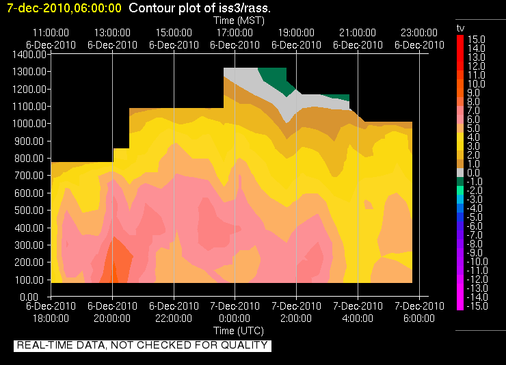
We have two soundings for 00 UTC on the 7th (5 PM local), both of which show very similar profiles. A fairly shallow and nearly isothermal layer extends from the surface, capped by a well mixed (dry adiabatic profile). In fact these soundings even support the possibilty of some weak convection (assuming it a parcel can either be lifted out of the shallow stable layer or from an elevated source... like the mountains). This potential was realized shortly after these soundings as a semi-organized band of precipitation pushed across the Wasatch Front providing locally heavily rain (in the mountains there was a lot of graupel). A big question for us was what happended during this period (around 02 UTC Dec 7th?). Fortunately we have some continuously monitoring intstruments to help figure that out, namely the Radio Acoustic Sounding System (RASS). Data indicated that around the time of this precipitaiton, a monotonically decreasing temperature profile existed with a fairly consistent lapse rate. See for yourself here. This would suggest that during the rain fall and convective burst that the atmosphere was able to freely mix for some short period of time. So was the cold pool dead as of then?

The plot thickens as we look at the 06 UTC sounding. Despite the rain and convection, we once again observe a shallow isothermal layer. If the cold pool was destroyed previously where did this layer come from and why is it so similar in structure to that observed before the rain?
By Wednesday morning (12 UTC Dec 7 th), conditions at the surface had cooled a bit, converting the previously isothermal layer to a true inversion. The air above this layer was once again nearly dry adiabatic. The more significant change observed at this time was appearance of a subsidence inversion aloft, indicative of large scale processes that would soon favor the trapping of air within the valley. But there was another variable, SUN!
Daytime heating, something that had been in short supply, helped to remove the surface based inverison by late moring (18 UTC) favoring a lapse rate that was close to moist nuetral up through 700 hPa. A tell tale sign of surface heating was observed at this time... fair weather cumulus over the valley (not just the mountains). The 00 UTC sounding further coroborates this notion showing a nearly dry adiabatic lapse rate from the surface up to the lowering subsidence inversion, which was now just below the crest level of the Wasatch Mountains.
So IOP 1 ended either during the mix out phase near 02 UTC on Dec 7th or during the day on Tuesday (between 12 UTC and 00 UTC) right? And IOP 2 began as the new subsidence inversion descended into the valley...
Well it did in our books, but there is a bit of a hitch and its name is the Great Salt Lake. While the atmosphere was well mixed over the land, surface observations (shown below) indicated that the lake remained cold and foggy (not shown, but RH values > 95 %) during this time.

We would in fact see the influence of the lake on Wednesday, as a lake front was observed which advected colder and damper air into the Salt Lake Valley during the afternoon. That air was the remains of the Cold Pool from IOP 1... so did it ever end? In the end it is just a semantic issue, but it certainly highlights the potential for the lake to act as a source of cold and poluted air.
The wind transition associated with that lake front was well captured by the U of U mini Sodar deployed at the Playa site near the lake. Note the strong and organized NW flow near 21 UTC:

We have scaled back observations for IOP 2 to conserve resources, but we are still very much in the midst of a persistent cold air pool. A weak system on Friday will try to mix it out, but it doesn't look promising. Over the weekend a strong ridge will build across the Mountain west and Cold Air Pool conditions are expected!
No comments:
Post a Comment