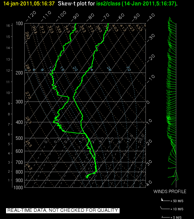
Thursday, January 27, 2011

Thermally driven flows.

Today was a great day of observations attempting to capture aspects of thermally driven flows within the current Cold Air Pool.

Canyon IOP:
We managed to coordinate 5 radiosondes this morning, two within the valley (one of which was the NWS Operational sounding) and three running up Parley's Cayon, a major drainage to the East of Salt Lake. We've been speculating for a long time that the nocturnal drainage flows down this particular 'airshed' are of particular importance to the mass budget and cold air accumulation within the Salt Lake Valley. Now we have some data to help elucidate some of these processes. We also have the first hand experience of just how cold and windy it was. After launching a balloon half way up the canyon this morning (which took about 1.5 hrs) it took me a full 3 hours under a thick blanket to warm back up.
We'll do the same thing on Friday, and with clear skies overhead the drainage flow could be even more pronounced. In addition we may have some clouds and fog in the valley which may help to visually demonstrate the degree to which the drier canyon flows penetrate into the valley cold air pool.


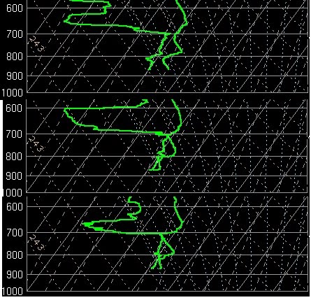
Side wall IOP and convective boundary layers

We also launched balloons this morning and afternoon to look at difference along the east and west side walls of the salt lake valley. The idea here is that differential heating caused by the changing sun angle over the course of the day may create local thermal flows favoring east-west asymetries in the cold pool structure. We also got to observe the growth of the convective boundary layer within the bottom portion of the cold air pool.


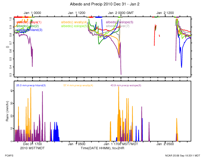
Regional Flows and Lake Breezes.

Another topic for thermally driven flows is the regional scale diurnal wind reversal that occurs during daytime heating. In the morning hours the salt lake valley exhibits organized Southeasterly drainage flow towards the lake, which is the low point. In the afternoon, if sufficient solar heating occurs, the flow reverses to an up valley flow from the NW. When this reversal occurs there is sometimes also an embedded more local lake breeze that develops due to the heating differences of the water and land surfaces. We saw both of these occur today with some portions of the valley experiencing spikes in the dewpoint temperature as lake air was advected into town. Just after sunset there was also a fog front that moved in from the NW obscuring portions of the downtown area. Fog was much more extensive in valleys to our west, and some of this 'fog front' may have moved in from the Toole valley. 'Interbasin' exchanges of air such as this are a big complicating factor on our cold air pools.


We're looking forward to the next few days of intense observations and hope to share some more of the data with you soon.

Tuesday, January 25, 2011

A Ridge to Remember?

Forecast model are indicating the first long-lived cloud-free ridge of high pressure during the PCAPS field campaign will begin building into Northern Utah on Wednesday and strengthen through Friday before flattening and weakening thereafter. Dozens of PCAPS volunteers are preparing for major observational operations into the weekend. Winds will be light above the inversion and skies will be mostly clear outside of patchy fog (the amount of fog remains an unknown). Several nights of radiational cooling will likely be experienced, which will allow for strengthening of the inversion from below. This will be in stark contrast to recent PCAPS IOPs, where most of the inversion strength was due to warming aloft versus radiational cooling at the surface. The lack of surface radiational cooling effects during most PCAPS IOPs to date is largely due to the record amount of cloud cover experienced over the region the last 6 weeks. Numerical forecast models are hinting at a pronounced inversion but these models may be underforecasting the amount of surface cooling, particularly with an unexpected fresh coat of snow on the ground. The NAM forecast for Friday morning has temperatures in the SL Valley near -3 degrees Celsius while warming to over 2 degrees C at mountaintop level (see image). In addition to the surface cooling, decent warming aloft will also will also occur, with mountaintop temperatures warming from -8 degrees Celsius Tuesday night to around 2 degrees Celsius on Friday. Large-scale operations looking at multiple aspects of the cold air pool evolution are planned Wednesday-Saturday. Let's hope that the clouds stay away and the nighttime cooling happens as planned.

Monday, January 17, 2011

A Tale of Two Valleys

IOP6, which was arguably the rainiest, cloudiest IOP in a long string of cloudy persistent cold air pools we have seen this winter ended around noon Monday with strong westerly flow mixing away a shallow surface inversion. The surface temperatures in the Salt Lake Valley are topping out in the mid to upper 50s Monday afternoon as the remaining snowfall quickly melts. The clean air and mild temperatures are a welcome sight for resident in the area tired of poor air quality and cold snowy conditions we have seen the last few weeks.

An interesting feature of the end of IOP6 was the resurgence of an extremely shallow surface temperature inversion Sunday night into Monday morning as seen in the 1200 UTC Salt Lake City sounding:

We did not expect a surface inversion like the one observed after a night of rain and clouds. What was the source of the low-level inversion? A strong possibility is Utah Valley. Mesowest observations and visual inspection has indicated that the inversion in Utah Valley has remained stronger and deeper over the past 24 hours than in the Salt Lake Valley. For instance, let us compare the temperature evolution at KSLC and at Lehi:


We can see that the surface temperatures in the Lehi area have averaged around 10 degrees F cooler than at Salt Lake City over the past 12 hours, although the inversion has been weakening at both sites on Monday. Observations near the point of the mountain also indicate that there was a southerly drainage flow coming out of the Utah Valley into the Salt Lake Valley overnight. We often stress the importance of cold air from the Great Salt Lake "recharging" the low-level temperature inversion in the Salt Lake Valley but give lesser importance to the Utah Valley as a source of cold air. A photo taken by John Horel looking into the Utah valley early Monday afternoon indicated that the CAP was still in place in the Utah Valley while the SL Valley had "cleared up." Future analysis of this and other IOPs will need to attempt to quantify the importance of basin-to-basin exchange in the evolution of persistent cold air pools and why the Utah Valley was so much colder than the Salt Lake Valley in this particular situation.


Friday, January 14, 2011

Evaporative Cooling and Mysterious Warming

We are now in IOP 6 which is shaping up to be yet another long lived event with significant air quality ramifications.

The previous 24 hours have been fascinating with some changes in the cold air pool which were explicable and others that were not. To set the stage, we started the day on Thursday with a very sharp low level temperature inversion in place.


Then in the late afternoon and overnight hours a short wave trough moved into the region spreading light to moderate snowfall across the valley. As snow fall intensified around 10 PM the lower troposphere became almost completely saturated.

The surface temperatures did not change much, however in the layer of air near 800 hPa, which had been above freezing, a combination of evaporative (or sublimation) cooling and the melting of snow falling from aloft caused the temperature to decrease to just below the freezing point. This effectively weakened the total inversion strength but not nearly to a degree that would allow vertical mixing of the air. Nonetheless, pollutant levels dropped significantly, a change which was presumable do the the scouring of aerosol by the snow. This is also known as wet deposition. Some scientists in the Biology department were out collecting data from the snow pack today to see if this was in fact the case.

All of the above changes were quite easy to make sense of, but some of the changes this morning were a bit stranger. The layer of air which had been cooled seemingly spontaneously warmed again, climbing well above freezing:


In fact for a very brief period the airport weather observations indicated some freezing rain, which suggests that precipitation falling from mid level clouds was melting in the warm layer and then becoming supercooled in the shallow layer of air below freezing at the surface. Freezing rain is actually a very rare event in Utah, and it tends only to occur in situations like these.
The big question is why and how did this layer warm so quickly following the cessation of the strong precipitation. Some form of advection is likely responsible, but the source of the warm air remains a mystery.

In addition to the warming, we can also see from the above soundings that the inversion, while still very sharp, is shallower this morning than it was yesterday. In fact as of 11 AM this morning it was only about 500 meters deep. This means that the mixing volume for pollutants is quite small, and correspondingly the decrease in PM2.5 seen last night has quickly reversed with levels now spiking to 58 ug/m^3 (the NAAQS is 35).

The forecast remains quite complex for the next few days with minor disturbances rippling across the region keeping periods of clouds and light precipitation in the mix. We'll have to see how each successive event impacts both the thermal structure and the concentration of pollutants.

Sunday, January 9, 2011

Inversion - A Misnomer

Inversion is a short name for temperature inversion. A temperature inversion is a high stability layer in the atmosphere where temperature, rather than showing its normal decrease with height, increases with height. Such layers are often surface-based, with coldest temperatures at the surface and temperatures increasing with height above the surface. Such surface-based inversions are usually formed at night and in winter when the ground cools faster than the air above. In fact, inversions are a common nighttime feature year around, since cold temperatures near the ground are produced commonly after sunset when the ground loses heat through outgoing long-wave radiation.

Temperature inversion layers can also form in the free atmosphere above the surface. This often happens when warm air is advected (i.e., blown in) above a layer of cold air.

The word 'inversion' is used in the local newspapers to refer to the mid-winter pollution events that affect the Salt Lake Valley. Inversions and pollution layers are, in fact, not synonymous. Inversions are a meteorological phenomenon; pollution is produced by a variety of human activities. Pollution can be emitted into and stored in a layer of high atmospheric stability, such as a temperature inversion, but the atmosphere, even when temperature does not increase with height, has sufficient stability to store pollutants and keep them from mixing vertically. In fact, the atmosphere in the Salt Lake Valley in winter, when polluted, is often isothermal, with temperature being more or less constant with height. Further, non-polluted inversions can form in areas where pollution sources are not present. The Salt Lake Basin is a topographic basin where stable layers (including inversions) often form, but the air pollution problem is not caused by inversions, it is caused by pollutants that are emitted into the stable layers. The solution to our pollution problem must come from reducing pollutant emissions. In the meantime, our PCAPS meteorological research program is gaining a better understanding to the meteorological processes that lead to the formation, maintenance and destruction of stable layers within the Salt lake Valley, and we hope this will, with effort, lead to improvements in forecasting stable layer and pollution events.

Friday, January 7, 2011

Fog, Stratus, and Smog. Oh My!


Living in Utah is quite a privilege, most of the time. But experiencing cold air pools like the present one is not the best of times. Everyone down in the Salt Lake Valley has been exposed to a mystery brew of fog, stratus, and smog for the past 24 hours. The composite image above was taken from the Suncrest development at the south end of the valley this evening. It's impossible to see anything down in the Valley, but the the Oquirrhs are in the distance to the left and Lone Peak is to the right.

We're now in day 7 of IOP-5 with ~30 hours to go. This event has had a number of unexpected features, but we're now locked into the most intense part of the event in terms of one measure of cold-air pools: the deficit in temperature air from a particular level would have if it was lifted upwards without exchanging heat to the level of the top of the Wasatch (~3000 m). The larger the deficit, the more negatively buoyant the air is, and the greater tendency for the air to sink back to its original level. The observed temperature deficits this morning of over 25 C are pretty impressive (the purple shades in the accompanying figure). These deficits and the cold air pool won't be wiped out until the next push of cold air begins to move in aloft Saturday night.

That'll usher in a welcome breath of fresh air.

Tuesday, January 4, 2011

Chasing the Clouds/Fog

Monday began with clear skies in the Salt Lake Valley with models predicting a low level cloud/fog deck forming during the evening/overnight hours. Based on this, we began increased operations at the ISS beginning with a 21Z launch and continuing at 3 hour increments through 12Z this morning. The goal was to capture the evolution of the predicted low level (below 800 hPa) cloud/fog layer.

The soundings show an evolution that is quite different from what we expected. While a shallow layer near 800 hPa does reach saturation overnight and persists through the evening, the valley never “socks in” with low level clouds as predicted by the NAM. We suspect that the discrepancy between the model forecast and the observed soundings is related to the model failing to predict the very shallow cloud layer near 700 hPa. This cloud layer altered the longwave radiation balance in the lower atmosphere, preventing the lowest layers from cooling and reaching saturation. Radiative cooling is evident at the top of this cloud layer which leads to a nearly dry adiabatic layer between 800 hPa and 700 hPa as seen in the 09Z sounding.

The image below shows the 21Z, 03Z and 09Z ISS soundings from top to bottom.


Light snow flurries have been observed overnight and this morning, likely due to a combination of a very weak shortwave trough passage and possible radiative effects discussed above.

Heading into Wednesday and beyond, the NAM continues to predict moist conditions from the surface up to a lowering inversion near 750-800 hPa through the duration of this event. It appears that it will dry out a bit above the inversion top, at least in the next 24-36 hours, with a very weak short wave ridge passing overhead.

We have gone back to 6 hourly launches at the ISS with possible operations planned tomorrow afternoon/evening to capture the potential onset of dense fog in the valley. Conditional graw launches are planned for Wednesday afternoon/evening as well as Thursday morning, most likely near the lake. Mobile weather stations will also be operated during this time.


-Chris Ander

Monday, January 3, 2011

Some of the Unanticipated Things That Happen During a Field Project


We're at the mid point of the PCAPS field project, so here's a few oddities that have happened that we weren't planning on:
  • 3 cans of beer mysteriously appearing during the setup at one of the ISFS sites (friendly neighbors or leftovers from a night of partying?)
  • extensive field notes blowing off into the Copper Mine
  • a homeowner's wireless router being mangled when installing a camera
  • the second leak of the Chevron pipeline adjacent to our Mountain Met Lab (see above photo of Chevron cleanup crew working early on New Year's Day morning)
  • ground critters chewing up a soil temperature sensor cable at the Flight Park site
Not entirely unexpected is the harsh environment in which the weather stations are placed. Riming at the crest of the Traverse Range reflects the kinds of conditions experienced more frequently back east rather than that usually expected at low elevations in the Wasatch (6300 ft). The wind sensor at SM1UU "locked up" when the winds from the north decreased on New Year's Eve, while SM2UU (located 500 ft lower) remained rime free and exhibited a wind shift to the southeast at that time. Evident in the photo is that SM1UU then continued to experience riming so that the radio antenna and other equipment were equally rimed from both directions. And as might be expected, it is up to our able group of graduate students and staff to solve the unexpected. In this case, Chris Ander had to climb up on the tower to clear off the rime.

As IOP-5 unfolds this first week of January, we're expecting more of the unexpected. More importantly for the science goals of our field study, will we end up transitioning in the next 12-24 hours to a stratus cloud deck, ice fog, or hoar frost coating objects on Tuesday and/or Wednesday? We're now launching rawinsondes at the ISS site every 3 hours to monitor this potential evolution from a "dry" cold air pool to a "wet" one.


Sunday, January 2, 2011

IOP 5: Clouds: Up High and Down Low?

Broken mid and high level clouds have moved over the Salt Lake Valley on Sunday night drastically altering the surface energy balance. In contrast to last night, the surface is only slowly cooling this evening as downwelling long wave radiation from the cloud bases alters the surface energy balance. Most sites are now reporting only a slightly negative net radiation, indicative of minor cooling. However, satellite imagery suggests that some clearing may occur for the second half of the night, which could lead to a deeper nocturnal inversion.

The nocturnal inversion isn't the only game in town though, with much of the stability found within the valley residing a sharp elevated inversion layer that formed due to subsidence and warm air advection (with some contribution from nocturnal cooling in its lowest portions).

Within this inversion layer there now appears to be a moistening layer which is seemingly close to forming clouds. This is very much in keeping with some of the model indicated evolution for this event and part of what we are hoping to observe overnight tonight and into the day tomorrow. The formation of clouds is both interesting in terms of deciphering the source of the moisture, but also because when (and if) clouds form, the nature of the cold air pool is drastically altered. Cooling is then driven by cloud top radiation while the layers below the clouds are dominated by overturning generated by negatively buoyant parcels.

Now it is just a waiting game to see what comes to pass.

Saturday, January 1, 2011

IOP 5: Off to the races

TONIGHT

The surface cooling has begun in earnest and now the question is how low will we go.The two key factors working in our favor are fresh snow cover and clear skies.

During the day on Saturday the high albedo of the fresh snow helped to limit the amount of solar heating throughout the Salt Lake Valley. This was especially true at the Playa ISFS site, where the reflection of incident solar radiation was so complete that the surface energy balance (the difference between the incoming and the outgoing radiation) remained negative throughout the day... which means that even in the peak of the solar day the surface was cooling not warming!

Now as night falls, the high emissivity of the fresh snow allows it to radiate in close approximation to a perfect black body... in other words it is really good at getting cold. And cold it is getting! In the hours following sunset the temperature at the Playa site plummetted to -5 F.

Most of the other sites around the valley are still much warmer (around 10 F), which may reflect the role that the urban landscape plays on altering the surface energy balance.


While it is tempting to think that the whole valley is covered in snow, a perspective from the foothills this evening revealed that within the urban/suburban portions of the valley the non-native trees, buildings, plowed road ways, etc all provide a decidedly darker and more absorptive surface than the snow cover found on the natively vegitated playa locales to the west. During the day this means that surfaces get warmer and heat the air above more effectively. At night the treed and developed landscape limits the sky view from the surface, which means more of the outgoing longwave radiation is "trapped" by the urban "canopy" which in turn diminishes the cooling potential.


TOMORROW

The focus for tomorrow will turn to the potential for dense clouds and fog to develop within the boundary layer. Models are suggesting that sometime late Sunday that the lower levels will begin to significantly moisten eventually leading to clouds by Monday morning. We'll be increasing our temporal sampling during this period to try to quantify the moistening and to isolate where the additional water vapor is coming from... our guess is either influences of the Great Salt Lake or sublimation from the snow pack.


NAM Potential Temperature Time Height. Clouds are indicated in white.