The previous 24 hours have been fascinating with some changes in the cold air pool which were explicable and others that were not. To set the stage, we started the day on Thursday with a very sharp low level temperature inversion in place.

Then in the late afternoon and overnight hours a short wave trough moved into the region spreading light to moderate snowfall across the valley. As snow fall intensified around 10 PM the lower troposphere became almost completely saturated.
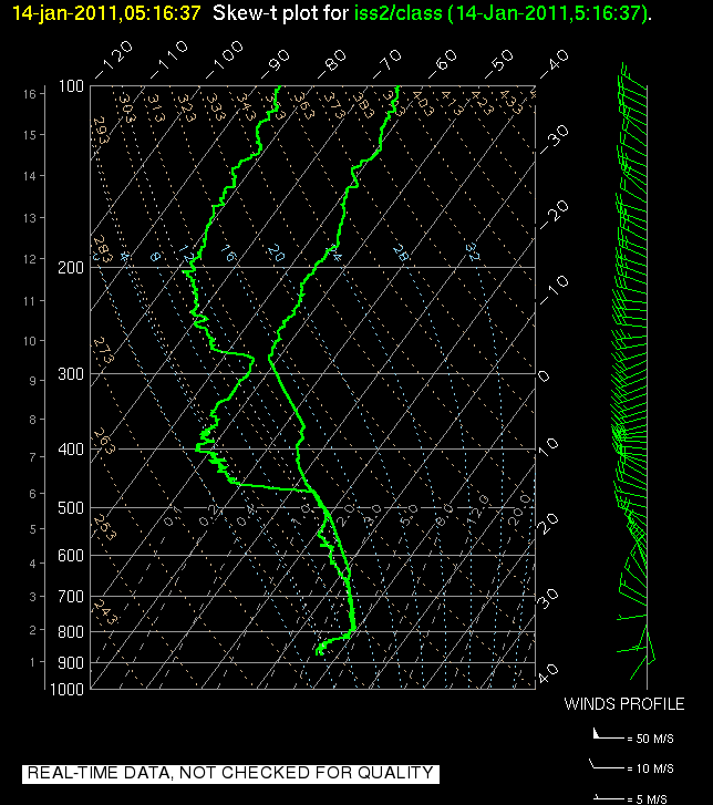 The surface temperatures did not change much, however in the layer of air near 800 hPa, which had been above freezing, a combination of evaporative (or sublimation) cooling and the melting of snow falling from aloft caused the temperature to decrease to just below the freezing point. This effectively weakened the total inversion strength but not nearly to a degree that would allow vertical mixing of the air. Nonetheless, pollutant levels dropped significantly, a change which was presumable do the the scouring of aerosol by the snow. This is also known as wet deposition. Some scientists in the Biology department were out collecting data from the snow pack today to see if this was in fact the case.
All of the above changes were quite easy to make sense of, but some of the changes this morning were a bit stranger. The layer of air which had been cooled seemingly spontaneously warmed again, climbing well above freezing:

In fact for a very brief period the airport weather observations indicated some freezing rain, which suggests that precipitation falling from mid level clouds was melting in the warm layer and then becoming supercooled in the shallow layer of air below freezing at the surface. Freezing rain is actually a very rare event in Utah, and it tends only to occur in situations like these.
The big question is why and how did this layer warm so quickly following the cessation of the strong precipitation. Some form of advection is likely responsible, but the source of the warm air remains a mystery.
In addition to the warming, we can also see from the above soundings that the inversion, while still very sharp, is shallower this morning than it was yesterday. In fact as of 11 AM this morning it was only about 500 meters deep. This means that the mixing volume for pollutants is quite small, and correspondingly the decrease in PM2.5 seen last night has quickly reversed with levels now spiking to 58 ug/m^3 (the NAAQS is 35).
The forecast remains quite complex for the next few days with minor disturbances rippling across the region keeping periods of clouds and light precipitation in the mix. We'll have to see how each successive event impacts both the thermal structure and the concentration of pollutants.
No comments:
Post a Comment