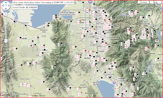
It is satisfying when forecaster intuition adds value to the model out put. Such was the case last night. Despite the dainty surface cold pool projected by the models, a more robust nocturnal inversion formed during the clear overnight hours. Strong drainage flow was observed from the major canyons and some truly frigid temperatures could be found throughout the Salt Lake and adjacent valleys.
The 12 UTC sounding shows both the existence of the surface based inversion and indicates that the strong subsidence layer has descended to crest level as expected. The elevated subsidence inversion was also evident in mountain top observations where warming and drying were observed. Between these two layers a region of much weaker static stability is found.
While it is tempting to assume that the whole valley is represented by this sounding, significant variations in temperature and cold pool structure are suggested by some of the observations in the south end of the valley near the Jordan Narrows and the Traverse Ridge.
Examining the temperature time series at 4 stations (Point of the Mountain, Flight Park, Bluffdale, and a site near Bangeter Highway) drastic differences in the temperature evolution are apparent.
The flight park and I-15 Point of the Mountain both show nearly steady cooling through the night. The 'Murray' site shows rapid cooling with a potent cold pool forming and temperatures near 0 F, then a rapid temperature increase. The Bluffdale site has more modest cooling, interrupted towards morning by successive temperature jumps and drops.
Taking a cursory look at the data from the ISFS sites around the valley we can see that this temperature jump behavior is unique to this portion of the valley. The Riverton site behaves similarly to the 'Murray' site, with a rapid warm up before 12 UTC. The other sites show a more consistent behavior and can roughly be subdivided into two groups (indicated by the departures from the group mean plot below), those that develop robust cold pools (the cold group) and those that experience less cooling.
What drives these variations? It is difficult to say.... internal turbulence and strong associated heat flux? Hydraulic jumps in the stable flow near terrain? Sloshing of the cold pool? These are all questions that we hope to be able to further explore during PCAPS.
Further complexities within the cold pool developed during the day as some locations where able to mix out the nocturnal surface based cold pool, a substantial accomplishment in light of the snow pack on the ground. Nonetheless the strong subsidence inversion descended further below crest level, keeping the valley air trapped in place. Above this inversion, thick altostratus moved in during the afternoon and some very weak radar returns are now apparent. Just what changes are in store for the cold pool structure overnight?
Here is the starting point this evening... what will we see in the morning?
OPERATIONS NOTE: ISS soundings at 18 UTC and 06 UTC will commence tomorrow (Dec 1st) and continue until the demise of the current cold pool which is currently anticipated to occur on Dec 3rd.
Tuesday, November 30, 2010
Monday, November 29, 2010
And so it begins. IOP 1 sort of...
Following the passage of a cold trough that brought significant snowfall to all of the Salt Lake Valley conditions are seemingly ripe for a cold pool to form as a ridge builds into the region from the west. Strong subsidence warming is expected near crest level, but at issue is the degree to which a nocturnal surface based inversion forms under the partly cloudy skies on Monday night. Models have suggested that the boundary layer will remain fairly well mixed through the night... however forecaster intuition would suggest that the widespread snow pack and only partly cloudy skies will favor rapid cooling at the surface. While the 00UTC sounding from the Salt Lake airport does indicate a relatively well mixed lower troposphere,
surface observations show rapid cold pool formation in the neighboring valleys and more modest cooling within the Salt Lake Valley proper. This pattern is quite familiar as the less urban and more natively vegitated Rush and Tooele valleys tend to develop stronger nocturnal cold pools. Within the Salt Lake Valley many stations have shown their typical diurnal windshift to the SE which is a well known indicator thermally driven drainage flows, and presumably a precursor to the formation of a nocturnal surface based inversion.
Infrared satellite images after sunset also indicate that skies are mostly clear and the surface is in fact largely snow covered and quite cold especially compared to the nearby Great Salt Lake. Good conditions for a cold pool if you ask me.
Beyond tomorrow the future of this event becomes less certain with thick altostratus possible, a very weak shortwave trough, and then continued 'dirty' ridging expected. It will be of great interest to our group to see how the cold pool responds to these variations.
With the official start of PCAPS just two days away, if this event comes together as we currently anticipate we will start operations in the midst of a Cold Air Pool. The PCAPS team hopes to use this event as our first IOP, though we will be scaling back from full operations and using this event as a shakedown for our operations, forecasting, data analysis, communications and decision making processes. The current plan, pending revision, is to use twice daily (18 and 06 UTC) NCAR ISS balloon launches to supplement the NWS operational soundings and to monitor the continuously operating observation platforms.
Now I guess we'll just have to wait and see how much cooling occurs tonight.
Subscribe to:
Posts (Atom)