Friday, December 31, 2010

IOP 5: The big one?

With the new year comes a new cold air pool, and this one could be the big one we've been hoping for. More on that in a moment, but first I'd like to reflect a bit on what we've learned thus far through one month of operations that involved 4 IOPs and numerous sub-IOPs.
Potential temperature deficit for the month of December as a function of height and time.
Values are calculated relative to a dry adiabat from the mountain top crest level.


I think the most significant realization that we've come to is that cold air pools are essentially the climatological base state during the heart of the winter when the sun angle is low. And to that end, it is more the lack of solar heating than the prominance of nocturnal cooling that seems to allow these events to persist for days at a time. I say this because December has been one of the cloudiest winter months in memory in Salt Lake... and the presence of clouds has severely limitted the number of nights with strong radiational cooling. Instead the synoptic-scale flow has frequently produced warming (advective and subsidence) in the lower mid levels (600-700 hPa) that has effectively capped the valley's of the great basin. The lack of surface heating then limits our ability to 'burn through the cap.' So it has been warming above, not cooling below that has generated most of our stability (although we have had a few nights were cooling played a big role).

Furthermore, we went into the project expecting most of our events to occur during strong ridging... well we haven't seen many strong ridging situations, with the month as a whole having anomalously strong SW and moist flow, and yet we've had some impressive cold air pools. So while the synoptic flow has exerted a strong control on the strength of the cold air pools, it has done so in ways that we may not have expected. Its not all about ridging!

We've also had a chance to observe two break up periods during strong southerly winds. Data seems to reveal a competition between advective terms (forcing the cold air pool north) and density current or thermally driven terms (trying to drive the cold air pool to the south). As the balance between these terms shifts in time so does the position of the interface between the cold air pool and the dry, warm and well mixed air. The lake has also been seen to be a 'resevoir' of cold and moist air, which can contribute to the density current nature of the cold air pools.

Okay so now to IOP 5.

Ridging?... not exactly. Clear skies?... maybe. Warming aloft?... definitely. Snow on the Ground?... yes sir. Cold air intrusion?... You betchya!

A pretty good recipe for a persistent cold air pool.

The precondition for IOP 5 may be the single most important factor for what looks to be a very long lived event. An extremely cold air mass (-22 C at 700 hPa) has moved across Utah for the last day of 2010 and a combination of lake effect and frontal snow has left the salt lake valley coated in high albedo white. As the upper level cold air shifts east this weekend warm air will begin to move in aloft trapping residual frigid air in the valleys below... in other words, a Cold Air Pool (CAP).

With some clear skies likely tonight and through the weekend, we could see additional cooling at the surface. The snow on the ground may allow the surface energy balance to remain near zero during the daylight hours... which are still very short.

The best news from our perspective though is that currently there are no strong systems forecast to impact the area in the next 5 or so days (and if you believe the long range models, and I don't, none for 7 or more days). As such we are anticipating a very significant persistent cold air pool for the first week of 2011 and will be iniating IOP 5 tonight. Air quality will likely become an issue and fog and clouds may be possible as the event matures. We'll probably start some additional observations in the coming week to focus on some of these sub-processes.

What a great start to the new year... for us at least.


Tuesday, December 14, 2010

Lake breeze captured during glider flight

Yesterday December 13, 2010 part of the PCAPS team and volunteers headed out again to the Great Salt Lake for more glider "sounding" data. With a strong possibility for lake breeze development, we hoped to capture at least some of the event mid-day. Meeting around solar noon allowed for time to setup and train our volunteers in initializing GRAW sondes and configuring radios for communications.

Some of the Team: Erik Crossman, Chris Santacroce, Chris Ander, David Reim, Neil Lareau

Our pilot, Chris Santacroce, met us shortly after noon. Surface winds were strangely calm at the lake's edge, and after waiting for several minutes, Chris decided to make a no-wind launch with his powered paraglider.

Chris setting up the powered paraglider

The flight plan was to fly long north-south cross sections, stepping up 100m each leg. Half way through the 50 minute flight we noticed a strong increase in surface winds pushing off the lake. Temps dropped rapidly and rh values spiked. We managed to capture the lake breeze as Chris was sampling data at the inversion top, so changed plan and sampled an east-west cross section at the mixing level as the lake breeze persisted inland. No one anticipated the lake breeze to penetrate deep into the Salt Lake Valley, but within the hour it had channeled across the length of the valley into Sandy. This helped strengthen the inversion and justified one more sounding transect the next day at 12 and 18 UTC across the valley before ending sub IOP 3 operations.

Chris flying north over the GSL at 6000 ft MSL.

More analysis is needed on the data collected, and we hope to review this last glider data-set during the upcoming downtime as the next series of troughs move through northern Utah.

Sunday, December 12, 2010

IOP 3: How much cold air can we produce in one night?

IOP 3 is now underway, but it won't be for long as we are expecting a short lived event. But that is part of the point. We want to see how quickly the Salt Lake Valley can form a cold air pool under clear and calm conditions.

A strong ridge built across the region on Sunday, a scenario that we typically associate with cold pools during the winter months. However, with no cold air in place and thick clouds the preceding night, only modest stability was generated in the lower atmosphere leading into today. The clear skies today lead to significant surface heating, and the the atmosphere became nearly dry adiabatic through the mountain top level during the day. As a result temperatures in town spiked into the low 50s, which was a welcome change.

Tonight however, we expect to develop a substantial nocturnal inversion under clear and calm conditions. In fact we can already see this cooling in progress. The net radiation measurements from the evening are strongly negative, especially as compared to last night. The balloon launched at 06 UTC from the ISS facility now shows a strong inversion near the surface, which is very different than the sounding from the airport shortly after sunset.


One interesting observation is the weakening of the subsidence inversion near 700 hpa during the past 6 hrs. Loosing a strong cap aloft could have a big impact on the evolution of this event.

We're also launching additional balloons tonight and tomorrow morning from Antelope Island in order to observed the cooling that occurs in the boundary layer over the lake.

Tomorrow with clear skies again expected for at least part of the day we'll have a look at how much of the surface inversion is removed by surface heating, how the lowering subsidence inversion (if it still exists) may couple with the nocturnal inversion, and how the diurnal wind reversal advects air from over lake into the valley. We'll have the motorized gliders out for those operations!

On Tuesday if conditions warrant we'll then be looking at the potentially rapid break up of the cold air pool by strong winds associated with an approaching vigorous trough.

Friday, December 10, 2010

IOP2 Ends

Despite my forecasting thinking to the contrary, heavy rain, strong winds, and a potent frontal passage have removed the cold pool from the Salt Lake Valley bringing and end to IOP2. The lake tried to hold onto a shallow lens of cold air for a bit longer, but it too succumbed to the exchange of momentum from aloft. The differences in mix out time can be seen in the following figure:


The sharp temperature rise at the airport occurred about 6 hrs prior to the mix out at Hat Island in the middle of the (not so) Great Salt Lake. The temperature then crashed shortly later as a well defined surface front pushed south across the lake and into the Salt Lake Valley bringing heavy rain and then ice pellets and snow. Strong NW winds with gusts to 43 mph helped to ensure that any residual pockets of cold air at the surface were completely eradicated.


The view across the valley is now as clean as it ever is in the winter and we're all breathing a bit deeper this afternoon. Out next cold pool event looks to be a shorter lived episode (maybe around 72 hrs) starting on Saturday night or Sunday morning and persisting until sometime Wednesday.

Thursday, December 9, 2010

IOP 1: Fog front

Before PCAPS began, the team of U of U scientists met with some of the experts from the National Weather Service (NWS) here in SLC. We were curious as to what they considered to be the most pressing forecast challenge associated with Persistent Cold Air Pools (PCAPS). The onset of dense fog, particularly at the airport, was the unanimous reply.

Fog in some ways seems like an easy forecast issue. For fog to form the ambient air temperature must cool to its dew point, at which point water vapor is forced into condensate in the form of fog (or cloud) droplets. Alternatively, sufficient moisture can be added to air through evaporation from the ground (water vapor flux) or through evaporation from rain to bring the air to saturation. Easy right? In principal yes, in reality no.

Throughout much of IOP 1 the atmospheric boundary layer seemed continually on the verge of forming fog, and in fact on a few occasions the airport reported mist (which is basically thin fog), but no truly dense fog. In some ways the forecast question became "why isn't dense fog forming?", after all the air was nearly saturated, the ground was wet and cold with snow and melted snow, and overnight temperatures were within measurable accuracy of the dew point.

Things changed on Sunday Dec 5th.

Light rain fell on Saturday evening across the Salt Lake Valley and much of the northern Great Basin. As skies cleared behind the departing weak system and temperatures dropped, dense fogged formed over much of NW Utah and NE Nevada.


However, dense fog did not form within the Salt Lake Valley. There were some areas of mist overnight and in the morning, but nothing like what was seen over the west desert. Why? I have no clue. Something to do with the urban environment? maybe there were more clouds overnight due to the proximal Wasatch Range? Very tough to say.

Despite the lack of in situ fog production, SLC would not remain fog free for long! With strong differential daytime heating between fog covered areas and the sunnier Salt Lake Valley organized northerly flow developed which would soon advect a 'fog front' from our west and north into the valley. The airport was the first to see its arrival, which was marked by visibilty plummeting from 2 miles (haze and mist) to less than 1/8 of a mile which caused numerous delayed flights. By early afternoon downtown Salt Lake disappeared into the murky ground based cloud. A ragged boundary of fog continued to progress south through the valley throughout the afternoon, with all of the valley eventually 'going under' by dark. Visibility was minimal, and may even have played a major role in the crash of a small aircraft attempting to land near Ogden.

What tipped the scales to allow for dense fog versus thin mist? Was the precipitation contribution of moisture to the cold pool the straw that broke the camels back? What role did the melting snow play in both forming and maintaining the fog? And why did the Salt Lake valley behave so differently?

It is tough to draw any conclusion as of yet, but fortunately PCAPS has two phases: 1.) observing and 2.) analysis. The analysis of the data we collect now will be ongoing for years to come, and perhaps we'll be able to answer some of these questions.

IOP 1: Time of Death? IOP 2: Time of Birth?

Nature seems to shun the clean distinctions that we'd like to apply to it. Categorization is useful, but nearly always an over simplification. We've run into this issue as we try to decide when to end Intensive Operation Periods (IOPs) and when to initiate new ones. What constitutes the end of a Persistent Cold Air Pool? In general we assume that if the atmosphere experiences a period of free overturning (with respect to either a saturated parcel or a dry one), then the event is over. But then the question turns to issues of location... if it mixes out in town but not over the lake, is the cold air pool destroyed? What about if it retreats from the airport, showing a well mixed profile for an hour, but then returns the next hour?

This much we do know, we declared IOP1 to have ended sometime between 00 UTC on Dec 7th and 00 UTC on Dec 8th. The below figure summarizes the observed soundings from 12 UTC on the 6th through 00 UTC on the 8th.

The figures in black and green are sounding conducted at the PCAPS NCAR ISS facility, while those in white are from the NWS.


Probably the most signifacant changes occured during Monday morning, where the 12 UTC (5 AM local) sounding showed a strong surface based inversion with dry and warm air above. By 18 UTC (11 AM local) rain was falling across the valley and the temperature profile was very close to the wet bulb temperature shown in the earlier 12 UTC sounding (light blue line), indicating that evaporative cooling and moistening had been substantial. Despite the rain and nearly moist nuetral lapse rate, there remained a very shallow surface layer of cold air... the cold pool was not yet dead.

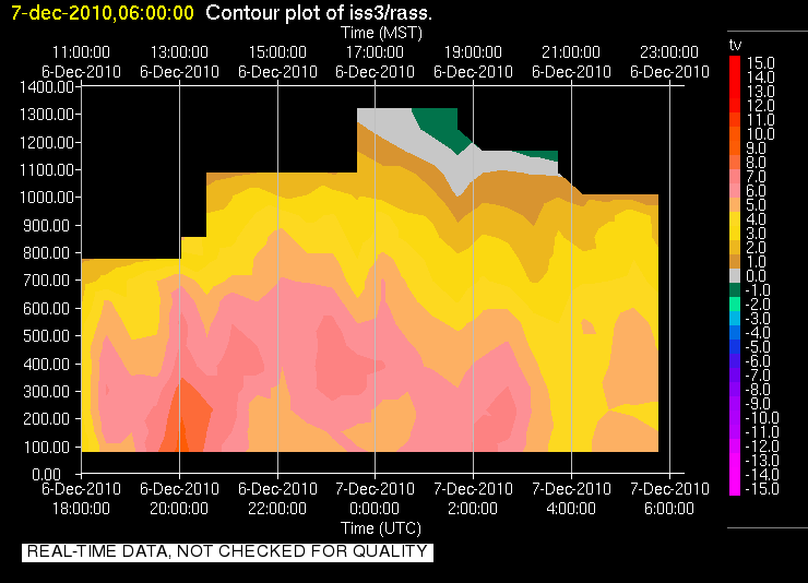
We have two soundings for 00 UTC on the 7th (5 PM local), both of which show very similar profiles. A fairly shallow and nearly isothermal layer extends from the surface, capped by a well mixed (dry adiabatic profile). In fact these soundings even support the possibilty of some weak convection (assuming it a parcel can either be lifted out of the shallow stable layer or from an elevated source... like the mountains). This potential was realized shortly after these soundings as a semi-organized band of precipitation pushed across the Wasatch Front providing locally heavily rain (in the mountains there was a lot of graupel). A big question for us was what happended during this period (around 02 UTC Dec 7th?). Fortunately we have some continuously monitoring intstruments to help figure that out, namely the Radio Acoustic Sounding System (RASS). Data indicated that around the time of this precipitaiton, a monotonically decreasing temperature profile existed with a fairly consistent lapse rate. See for yourself here. This would suggest that during the rain fall and convective burst that the atmosphere was able to freely mix for some short period of time. So was the cold pool dead as of then?


The plot thickens as we look at the 06 UTC sounding. Despite the rain and convection, we once again observe a shallow isothermal layer. If the cold pool was destroyed previously where did this layer come from and why is it so similar in structure to that observed before the rain?

By Wednesday morning (12 UTC Dec 7 th), conditions at the surface had cooled a bit, converting the previously isothermal layer to a true inversion. The air above this layer was once again nearly dry adiabatic. The more significant change observed at this time was appearance of a subsidence inversion aloft, indicative of large scale processes that would soon favor the trapping of air within the valley. But there was another variable, SUN!

Daytime heating, something that had been in short supply, helped to remove the surface based inverison by late moring (18 UTC) favoring a lapse rate that was close to moist nuetral up through 700 hPa. A tell tale sign of surface heating was observed at this time... fair weather cumulus over the valley (not just the mountains). The 00 UTC sounding further coroborates this notion showing a nearly dry adiabatic lapse rate from the surface up to the lowering subsidence inversion, which was now just below the crest level of the Wasatch Mountains.

So IOP 1 ended either during the mix out phase near 02 UTC on Dec 7th or during the day on Tuesday (between 12 UTC and 00 UTC) right? And IOP 2 began as the new subsidence inversion descended into the valley...

Well it did in our books, but there is a bit of a hitch and its name is the Great Salt Lake. While the atmosphere was well mixed over the land, surface observations (shown below) indicated that the lake remained cold and foggy (not shown, but RH values > 95 %) during this time.


We would in fact see the influence of the lake on Wednesday, as a lake front was observed which advected colder and damper air into the Salt Lake Valley during the afternoon. That air was the remains of the Cold Pool from IOP 1... so did it ever end? In the end it is just a semantic issue, but it certainly highlights the potential for the lake to act as a source of cold and poluted air.

The wind transition associated with that lake front was well captured by the U of U mini Sodar deployed at the Playa site near the lake. Note the strong and organized NW flow near 21 UTC:


We have scaled back observations for IOP 2 to conserve resources, but we are still very much in the midst of a persistent cold air pool. A weak system on Friday will try to mix it out, but it doesn't look promising. Over the weekend a strong ridge will build across the Mountain west and Cold Air Pool conditions are expected!

Tuesday, December 7, 2010

Morning inversion

This morning there was a pronounced nocturnal inversion visible across the Salt Lake Valley. The below photo was taken from above the Salt Lake City Cemetary at 11th Avenue around 9:30AM. What's interersting about this photo is the very distinct two layers against the East bench. Here we are looking south across the valley at Big and Little Cottonwood canyon in the distance.


Reviewing the 12z SLC sounding, there was a pronounced ground inversion capped at 860mb with a small flattening near 750mb and then a relatively deep layer extending up to 650mb. By mid day the entire valley was likely well mixed to 650mb with surface-driven cumulus across the region. And with a northwest flow aloft, perhaps we will see some of the trapped valley aerosols disperse a bit more before the next Cold Air Pool event settles in for a stay.


The ingredients are right for another Cold Air Pool event, which will give us IOP2 over the next period, but the duration and strength is in question. I'll let Neil or Erik post the details on IOP1 ending and IOP2 starting up.