Thursday, January 27, 2011

Thermally driven flows.

Today was a great day of observations attempting to capture aspects of thermally driven flows within the current Cold Air Pool.

Canyon IOP:
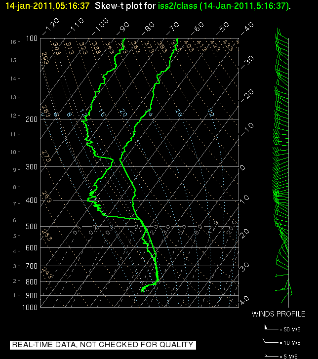
We managed to coordinate 5 radiosondes this morning, two within the valley (one of which was the NWS Operational sounding) and three running up Parley's Cayon, a major drainage to the East of Salt Lake. We've been speculating for a long time that the nocturnal drainage flows down this particular 'airshed' are of particular importance to the mass budget and cold air accumulation within the Salt Lake Valley. Now we have some data to help elucidate some of these processes. We also have the first hand experience of just how cold and windy it was. After launching a balloon half way up the canyon this morning (which took about 1.5 hrs) it took me a full 3 hours under a thick blanket to warm back up.
We'll do the same thing on Friday, and with clear skies overhead the drainage flow could be even more pronounced. In addition we may have some clouds and fog in the valley which may help to visually demonstrate the degree to which the drier canyon flows penetrate into the valley cold air pool.


Side wall IOP and convective boundary layers

We also launched balloons this morning and afternoon to look at difference along the east and west side walls of the salt lake valley. The idea here is that differential heating caused by the changing sun angle over the course of the day may create local thermal flows favoring east-west asymetries in the cold pool structure. We also got to observe the growth of the convective boundary layer within the bottom portion of the cold air pool.


Regional Flows and Lake Breezes.

Another topic for thermally driven flows is the regional scale diurnal wind reversal that occurs during daytime heating. In the morning hours the salt lake valley exhibits organized Southeasterly drainage flow towards the lake, which is the low point. In the afternoon, if sufficient solar heating occurs, the flow reverses to an up valley flow from the NW. When this reversal occurs there is sometimes also an embedded more local lake breeze that develops due to the heating differences of the water and land surfaces. We saw both of these occur today with some portions of the valley experiencing spikes in the dewpoint temperature as lake air was advected into town. Just after sunset there was also a fog front that moved in from the NW obscuring portions of the downtown area. Fog was much more extensive in valleys to our west, and some of this 'fog front' may have moved in from the Toole valley. 'Interbasin' exchanges of air such as this are a big complicating factor on our cold air pools.


We're looking forward to the next few days of intense observations and hope to share some more of the data with you soon.

Tuesday, January 25, 2011

A Ridge to Remember?

Forecast model are indicating the first long-lived cloud-free ridge of high pressure during the PCAPS field campaign will begin building into Northern Utah on Wednesday and strengthen through Friday before flattening and weakening thereafter. Dozens of PCAPS volunteers are preparing for major observational operations into the weekend. Winds will be light above the inversion and skies will be mostly clear outside of patchy fog (the amount of fog remains an unknown). Several nights of radiational cooling will likely be experienced, which will allow for strengthening of the inversion from below. This will be in stark contrast to recent PCAPS IOPs, where most of the inversion strength was due to warming aloft versus radiational cooling at the surface. The lack of surface radiational cooling effects during most PCAPS IOPs to date is largely due to the record amount of cloud cover experienced over the region the last 6 weeks. Numerical forecast models are hinting at a pronounced inversion but these models may be underforecasting the amount of surface cooling, particularly with an unexpected fresh coat of snow on the ground. The NAM forecast for Friday morning has temperatures in the SL Valley near -3 degrees Celsius while warming to over 2 degrees C at mountaintop level (see image). In addition to the surface cooling, decent warming aloft will also will also occur, with mountaintop temperatures warming from -8 degrees Celsius Tuesday night to around 2 degrees Celsius on Friday. Large-scale operations looking at multiple aspects of the cold air pool evolution are planned Wednesday-Saturday. Let's hope that the clouds stay away and the nighttime cooling happens as planned.

Monday, January 17, 2011

A Tale of Two Valleys

IOP6, which was arguably the rainiest, cloudiest IOP in a long string of cloudy persistent cold air pools we have seen this winter ended around noon Monday with strong westerly flow mixing away a shallow surface inversion. The surface temperatures in the Salt Lake Valley are topping out in the mid to upper 50s Monday afternoon as the remaining snowfall quickly melts. The clean air and mild temperatures are a welcome sight for resident in the area tired of poor air quality and cold snowy conditions we have seen the last few weeks.

An interesting feature of the end of IOP6 was the resurgence of an extremely shallow surface temperature inversion Sunday night into Monday morning as seen in the 1200 UTC Salt Lake City sounding:

We did not expect a surface inversion like the one observed after a night of rain and clouds. What was the source of the low-level inversion? A strong possibility is Utah Valley. Mesowest observations and visual inspection has indicated that the inversion in Utah Valley has remained stronger and deeper over the past 24 hours than in the Salt Lake Valley. For instance, let us compare the temperature evolution at KSLC and at Lehi:


We can see that the surface temperatures in the Lehi area have averaged around 10 degrees F cooler than at Salt Lake City over the past 12 hours, although the inversion has been weakening at both sites on Monday. Observations near the point of the mountain also indicate that there was a southerly drainage flow coming out of the Utah Valley into the Salt Lake Valley overnight. We often stress the importance of cold air from the Great Salt Lake "recharging" the low-level temperature inversion in the Salt Lake Valley but give lesser importance to the Utah Valley as a source of cold air. A photo taken by John Horel looking into the Utah valley early Monday afternoon indicated that the CAP was still in place in the Utah Valley while the SL Valley had "cleared up." Future analysis of this and other IOPs will need to attempt to quantify the importance of basin-to-basin exchange in the evolution of persistent cold air pools and why the Utah Valley was so much colder than the Salt Lake Valley in this particular situation.


Friday, January 14, 2011

Evaporative Cooling and Mysterious Warming

We are now in IOP 6 which is shaping up to be yet another long lived event with significant air quality ramifications.

The previous 24 hours have been fascinating with some changes in the cold air pool which were explicable and others that were not. To set the stage, we started the day on Thursday with a very sharp low level temperature inversion in place.


Then in the late afternoon and overnight hours a short wave trough moved into the region spreading light to moderate snowfall across the valley. As snow fall intensified around 10 PM the lower troposphere became almost completely saturated.

The surface temperatures did not change much, however in the layer of air near 800 hPa, which had been above freezing, a combination of evaporative (or sublimation) cooling and the melting of snow falling from aloft caused the temperature to decrease to just below the freezing point. This effectively weakened the total inversion strength but not nearly to a degree that would allow vertical mixing of the air. Nonetheless, pollutant levels dropped significantly, a change which was presumable do the the scouring of aerosol by the snow. This is also known as wet deposition. Some scientists in the Biology department were out collecting data from the snow pack today to see if this was in fact the case.

All of the above changes were quite easy to make sense of, but some of the changes this morning were a bit stranger. The layer of air which had been cooled seemingly spontaneously warmed again, climbing well above freezing:


In fact for a very brief period the airport weather observations indicated some freezing rain, which suggests that precipitation falling from mid level clouds was melting in the warm layer and then becoming supercooled in the shallow layer of air below freezing at the surface. Freezing rain is actually a very rare event in Utah, and it tends only to occur in situations like these.
The big question is why and how did this layer warm so quickly following the cessation of the strong precipitation. Some form of advection is likely responsible, but the source of the warm air remains a mystery.

In addition to the warming, we can also see from the above soundings that the inversion, while still very sharp, is shallower this morning than it was yesterday. In fact as of 11 AM this morning it was only about 500 meters deep. This means that the mixing volume for pollutants is quite small, and correspondingly the decrease in PM2.5 seen last night has quickly reversed with levels now spiking to 58 ug/m^3 (the NAAQS is 35).

The forecast remains quite complex for the next few days with minor disturbances rippling across the region keeping periods of clouds and light precipitation in the mix. We'll have to see how each successive event impacts both the thermal structure and the concentration of pollutants.

Friday, January 7, 2011

Fog, Stratus, and Smog. Oh My!


Living in Utah is quite a privilege, most of the time. But experiencing cold air pools like the present one is not the best of times. Everyone down in the Salt Lake Valley has been exposed to a mystery brew of fog, stratus, and smog for the past 24 hours. The composite image above was taken from the Suncrest development at the south end of the valley this evening. It's impossible to see anything down in the Valley, but the the Oquirrhs are in the distance to the left and Lone Peak is to the right.

We're now in day 7 of IOP-5 with ~30 hours to go. This event has had a number of unexpected features, but we're now locked into the most intense part of the event in terms of one measure of cold-air pools: the deficit in temperature air from a particular level would have if it was lifted upwards without exchanging heat to the level of the top of the Wasatch (~3000 m). The larger the deficit, the more negatively buoyant the air is, and the greater tendency for the air to sink back to its original level. The observed temperature deficits this morning of over 25 C are pretty impressive (the purple shades in the accompanying figure). These deficits and the cold air pool won't be wiped out until the next push of cold air begins to move in aloft Saturday night.

That'll usher in a welcome breath of fresh air.

Tuesday, January 4, 2011

Chasing the Clouds/Fog

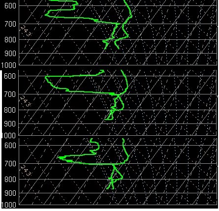
Monday began with clear skies in the Salt Lake Valley with models predicting a low level cloud/fog deck forming during the evening/overnight hours. Based on this, we began increased operations at the ISS beginning with a 21Z launch and continuing at 3 hour increments through 12Z this morning. The goal was to capture the evolution of the predicted low level (below 800 hPa) cloud/fog layer.

The soundings show an evolution that is quite different from what we expected. While a shallow layer near 800 hPa does reach saturation overnight and persists through the evening, the valley never “socks in” with low level clouds as predicted by the NAM. We suspect that the discrepancy between the model forecast and the observed soundings is related to the model failing to predict the very shallow cloud layer near 700 hPa. This cloud layer altered the longwave radiation balance in the lower atmosphere, preventing the lowest layers from cooling and reaching saturation. Radiative cooling is evident at the top of this cloud layer which leads to a nearly dry adiabatic layer between 800 hPa and 700 hPa as seen in the 09Z sounding.

The image below shows the 21Z, 03Z and 09Z ISS soundings from top to bottom.


Light snow flurries have been observed overnight and this morning, likely due to a combination of a very weak shortwave trough passage and possible radiative effects discussed above.

Heading into Wednesday and beyond, the NAM continues to predict moist conditions from the surface up to a lowering inversion near 750-800 hPa through the duration of this event. It appears that it will dry out a bit above the inversion top, at least in the next 24-36 hours, with a very weak short wave ridge passing overhead.

We have gone back to 6 hourly launches at the ISS with possible operations planned tomorrow afternoon/evening to capture the potential onset of dense fog in the valley. Conditional graw launches are planned for Wednesday afternoon/evening as well as Thursday morning, most likely near the lake. Mobile weather stations will also be operated during this time.


-Chris Ander

Monday, January 3, 2011

Some of the Unanticipated Things That Happen During a Field Project


We're at the mid point of the PCAPS field project, so here's a few oddities that have happened that we weren't planning on:
  • 3 cans of beer mysteriously appearing during the setup at one of the ISFS sites (friendly neighbors or leftovers from a night of partying?)
  • extensive field notes blowing off into the Copper Mine
  • a homeowner's wireless router being mangled when installing a camera
  • the second leak of the Chevron pipeline adjacent to our Mountain Met Lab (see above photo of Chevron cleanup crew working early on New Year's Day morning)
  • ground critters chewing up a soil temperature sensor cable at the Flight Park site
Not entirely unexpected is the harsh environment in which the weather stations are placed. Riming at the crest of the Traverse Range reflects the kinds of conditions experienced more frequently back east rather than that usually expected at low elevations in the Wasatch (6300 ft). The wind sensor at SM1UU "locked up" when the winds from the north decreased on New Year's Eve, while SM2UU (located 500 ft lower) remained rime free and exhibited a wind shift to the southeast at that time. Evident in the photo is that SM1UU then continued to experience riming so that the radio antenna and other equipment were equally rimed from both directions. And as might be expected, it is up to our able group of graduate students and staff to solve the unexpected. In this case, Chris Ander had to climb up on the tower to clear off the rime.

As IOP-5 unfolds this first week of January, we're expecting more of the unexpected. More importantly for the science goals of our field study, will we end up transitioning in the next 12-24 hours to a stratus cloud deck, ice fog, or hoar frost coating objects on Tuesday and/or Wednesday? We're now launching rawinsondes at the ISS site every 3 hours to monitor this potential evolution from a "dry" cold air pool to a "wet" one.


Sunday, January 2, 2011

IOP 5: Clouds: Up High and Down Low?

Broken mid and high level clouds have moved over the Salt Lake Valley on Sunday night drastically altering the surface energy balance. In contrast to last night, the surface is only slowly cooling this evening as downwelling long wave radiation from the cloud bases alters the surface energy balance. Most sites are now reporting only a slightly negative net radiation, indicative of minor cooling. However, satellite imagery suggests that some clearing may occur for the second half of the night, which could lead to a deeper nocturnal inversion.

The nocturnal inversion isn't the only game in town though, with much of the stability found within the valley residing a sharp elevated inversion layer that formed due to subsidence and warm air advection (with some contribution from nocturnal cooling in its lowest portions).

Within this inversion layer there now appears to be a moistening layer which is seemingly close to forming clouds. This is very much in keeping with some of the model indicated evolution for this event and part of what we are hoping to observe overnight tonight and into the day tomorrow. The formation of clouds is both interesting in terms of deciphering the source of the moisture, but also because when (and if) clouds form, the nature of the cold air pool is drastically altered. Cooling is then driven by cloud top radiation while the layers below the clouds are dominated by overturning generated by negatively buoyant parcels.

Now it is just a waiting game to see what comes to pass.

Saturday, January 1, 2011

IOP 5: Off to the races

TONIGHT

The surface cooling has begun in earnest and now the question is how low will we go.The two key factors working in our favor are fresh snow cover and clear skies.

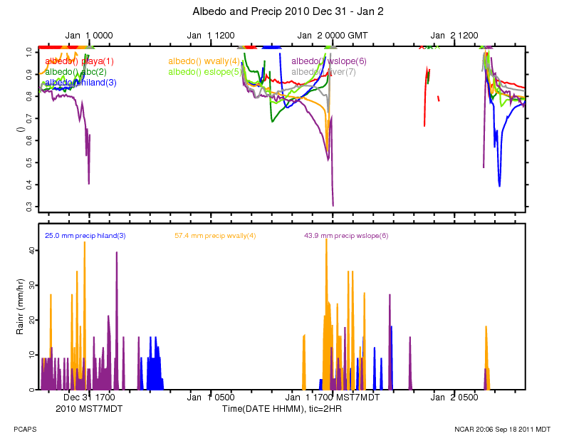
During the day on Saturday the high albedo of the fresh snow helped to limit the amount of solar heating throughout the Salt Lake Valley. This was especially true at the Playa ISFS site, where the reflection of incident solar radiation was so complete that the surface energy balance (the difference between the incoming and the outgoing radiation) remained negative throughout the day... which means that even in the peak of the solar day the surface was cooling not warming!

Now as night falls, the high emissivity of the fresh snow allows it to radiate in close approximation to a perfect black body... in other words it is really good at getting cold. And cold it is getting! In the hours following sunset the temperature at the Playa site plummetted to -5 F.

Most of the other sites around the valley are still much warmer (around 10 F), which may reflect the role that the urban landscape plays on altering the surface energy balance.


While it is tempting to think that the whole valley is covered in snow, a perspective from the foothills this evening revealed that within the urban/suburban portions of the valley the non-native trees, buildings, plowed road ways, etc all provide a decidedly darker and more absorptive surface than the snow cover found on the natively vegitated playa locales to the west. During the day this means that surfaces get warmer and heat the air above more effectively. At night the treed and developed landscape limits the sky view from the surface, which means more of the outgoing longwave radiation is "trapped" by the urban "canopy" which in turn diminishes the cooling potential.


TOMORROW

The focus for tomorrow will turn to the potential for dense clouds and fog to develop within the boundary layer. Models are suggesting that sometime late Sunday that the lower levels will begin to significantly moisten eventually leading to clouds by Monday morning. We'll be increasing our temporal sampling during this period to try to quantify the moistening and to isolate where the additional water vapor is coming from... our guess is either influences of the Great Salt Lake or sublimation from the snow pack.


NAM Potential Temperature Time Height. Clouds are indicated in white.

Friday, December 31, 2010

IOP 5: The big one?

With the new year comes a new cold air pool, and this one could be the big one we've been hoping for. More on that in a moment, but first I'd like to reflect a bit on what we've learned thus far through one month of operations that involved 4 IOPs and numerous sub-IOPs.
Potential temperature deficit for the month of December as a function of height and time.
Values are calculated relative to a dry adiabat from the mountain top crest level.


I think the most significant realization that we've come to is that cold air pools are essentially the climatological base state during the heart of the winter when the sun angle is low. And to that end, it is more the lack of solar heating than the prominance of nocturnal cooling that seems to allow these events to persist for days at a time. I say this because December has been one of the cloudiest winter months in memory in Salt Lake... and the presence of clouds has severely limitted the number of nights with strong radiational cooling. Instead the synoptic-scale flow has frequently produced warming (advective and subsidence) in the lower mid levels (600-700 hPa) that has effectively capped the valley's of the great basin. The lack of surface heating then limits our ability to 'burn through the cap.' So it has been warming above, not cooling below that has generated most of our stability (although we have had a few nights were cooling played a big role).

Furthermore, we went into the project expecting most of our events to occur during strong ridging... well we haven't seen many strong ridging situations, with the month as a whole having anomalously strong SW and moist flow, and yet we've had some impressive cold air pools. So while the synoptic flow has exerted a strong control on the strength of the cold air pools, it has done so in ways that we may not have expected. Its not all about ridging!

We've also had a chance to observe two break up periods during strong southerly winds. Data seems to reveal a competition between advective terms (forcing the cold air pool north) and density current or thermally driven terms (trying to drive the cold air pool to the south). As the balance between these terms shifts in time so does the position of the interface between the cold air pool and the dry, warm and well mixed air. The lake has also been seen to be a 'resevoir' of cold and moist air, which can contribute to the density current nature of the cold air pools.

Okay so now to IOP 5.

Ridging?... not exactly. Clear skies?... maybe. Warming aloft?... definitely. Snow on the Ground?... yes sir. Cold air intrusion?... You betchya!

A pretty good recipe for a persistent cold air pool.

The precondition for IOP 5 may be the single most important factor for what looks to be a very long lived event. An extremely cold air mass (-22 C at 700 hPa) has moved across Utah for the last day of 2010 and a combination of lake effect and frontal snow has left the salt lake valley coated in high albedo white. As the upper level cold air shifts east this weekend warm air will begin to move in aloft trapping residual frigid air in the valleys below... in other words, a Cold Air Pool (CAP).

With some clear skies likely tonight and through the weekend, we could see additional cooling at the surface. The snow on the ground may allow the surface energy balance to remain near zero during the daylight hours... which are still very short.

The best news from our perspective though is that currently there are no strong systems forecast to impact the area in the next 5 or so days (and if you believe the long range models, and I don't, none for 7 or more days). As such we are anticipating a very significant persistent cold air pool for the first week of 2011 and will be iniating IOP 5 tonight. Air quality will likely become an issue and fog and clouds may be possible as the event matures. We'll probably start some additional observations in the coming week to focus on some of these sub-processes.

What a great start to the new year... for us at least.


Tuesday, December 14, 2010

Lake breeze captured during glider flight

Yesterday December 13, 2010 part of the PCAPS team and volunteers headed out again to the Great Salt Lake for more glider "sounding" data. With a strong possibility for lake breeze development, we hoped to capture at least some of the event mid-day. Meeting around solar noon allowed for time to setup and train our volunteers in initializing GRAW sondes and configuring radios for communications.

Some of the Team: Erik Crossman, Chris Santacroce, Chris Ander, David Reim, Neil Lareau

Our pilot, Chris Santacroce, met us shortly after noon. Surface winds were strangely calm at the lake's edge, and after waiting for several minutes, Chris decided to make a no-wind launch with his powered paraglider.

Chris setting up the powered paraglider

The flight plan was to fly long north-south cross sections, stepping up 100m each leg. Half way through the 50 minute flight we noticed a strong increase in surface winds pushing off the lake. Temps dropped rapidly and rh values spiked. We managed to capture the lake breeze as Chris was sampling data at the inversion top, so changed plan and sampled an east-west cross section at the mixing level as the lake breeze persisted inland. No one anticipated the lake breeze to penetrate deep into the Salt Lake Valley, but within the hour it had channeled across the length of the valley into Sandy. This helped strengthen the inversion and justified one more sounding transect the next day at 12 and 18 UTC across the valley before ending sub IOP 3 operations.

Chris flying north over the GSL at 6000 ft MSL.

More analysis is needed on the data collected, and we hope to review this last glider data-set during the upcoming downtime as the next series of troughs move through northern Utah.

Sunday, December 12, 2010

IOP 3: How much cold air can we produce in one night?

IOP 3 is now underway, but it won't be for long as we are expecting a short lived event. But that is part of the point. We want to see how quickly the Salt Lake Valley can form a cold air pool under clear and calm conditions.

A strong ridge built across the region on Sunday, a scenario that we typically associate with cold pools during the winter months. However, with no cold air in place and thick clouds the preceding night, only modest stability was generated in the lower atmosphere leading into today. The clear skies today lead to significant surface heating, and the the atmosphere became nearly dry adiabatic through the mountain top level during the day. As a result temperatures in town spiked into the low 50s, which was a welcome change.

Tonight however, we expect to develop a substantial nocturnal inversion under clear and calm conditions. In fact we can already see this cooling in progress. The net radiation measurements from the evening are strongly negative, especially as compared to last night. The balloon launched at 06 UTC from the ISS facility now shows a strong inversion near the surface, which is very different than the sounding from the airport shortly after sunset.


One interesting observation is the weakening of the subsidence inversion near 700 hpa during the past 6 hrs. Loosing a strong cap aloft could have a big impact on the evolution of this event.

We're also launching additional balloons tonight and tomorrow morning from Antelope Island in order to observed the cooling that occurs in the boundary layer over the lake.

Tomorrow with clear skies again expected for at least part of the day we'll have a look at how much of the surface inversion is removed by surface heating, how the lowering subsidence inversion (if it still exists) may couple with the nocturnal inversion, and how the diurnal wind reversal advects air from over lake into the valley. We'll have the motorized gliders out for those operations!

On Tuesday if conditions warrant we'll then be looking at the potentially rapid break up of the cold air pool by strong winds associated with an approaching vigorous trough.

Friday, December 10, 2010

IOP2 Ends

Despite my forecasting thinking to the contrary, heavy rain, strong winds, and a potent frontal passage have removed the cold pool from the Salt Lake Valley bringing and end to IOP2. The lake tried to hold onto a shallow lens of cold air for a bit longer, but it too succumbed to the exchange of momentum from aloft. The differences in mix out time can be seen in the following figure:


The sharp temperature rise at the airport occurred about 6 hrs prior to the mix out at Hat Island in the middle of the (not so) Great Salt Lake. The temperature then crashed shortly later as a well defined surface front pushed south across the lake and into the Salt Lake Valley bringing heavy rain and then ice pellets and snow. Strong NW winds with gusts to 43 mph helped to ensure that any residual pockets of cold air at the surface were completely eradicated.


The view across the valley is now as clean as it ever is in the winter and we're all breathing a bit deeper this afternoon. Out next cold pool event looks to be a shorter lived episode (maybe around 72 hrs) starting on Saturday night or Sunday morning and persisting until sometime Wednesday.

Thursday, December 9, 2010

IOP 1: Fog front

Before PCAPS began, the team of U of U scientists met with some of the experts from the National Weather Service (NWS) here in SLC. We were curious as to what they considered to be the most pressing forecast challenge associated with Persistent Cold Air Pools (PCAPS). The onset of dense fog, particularly at the airport, was the unanimous reply.

Fog in some ways seems like an easy forecast issue. For fog to form the ambient air temperature must cool to its dew point, at which point water vapor is forced into condensate in the form of fog (or cloud) droplets. Alternatively, sufficient moisture can be added to air through evaporation from the ground (water vapor flux) or through evaporation from rain to bring the air to saturation. Easy right? In principal yes, in reality no.

Throughout much of IOP 1 the atmospheric boundary layer seemed continually on the verge of forming fog, and in fact on a few occasions the airport reported mist (which is basically thin fog), but no truly dense fog. In some ways the forecast question became "why isn't dense fog forming?", after all the air was nearly saturated, the ground was wet and cold with snow and melted snow, and overnight temperatures were within measurable accuracy of the dew point.

Things changed on Sunday Dec 5th.

Light rain fell on Saturday evening across the Salt Lake Valley and much of the northern Great Basin. As skies cleared behind the departing weak system and temperatures dropped, dense fogged formed over much of NW Utah and NE Nevada.


However, dense fog did not form within the Salt Lake Valley. There were some areas of mist overnight and in the morning, but nothing like what was seen over the west desert. Why? I have no clue. Something to do with the urban environment? maybe there were more clouds overnight due to the proximal Wasatch Range? Very tough to say.

Despite the lack of in situ fog production, SLC would not remain fog free for long! With strong differential daytime heating between fog covered areas and the sunnier Salt Lake Valley organized northerly flow developed which would soon advect a 'fog front' from our west and north into the valley. The airport was the first to see its arrival, which was marked by visibilty plummeting from 2 miles (haze and mist) to less than 1/8 of a mile which caused numerous delayed flights. By early afternoon downtown Salt Lake disappeared into the murky ground based cloud. A ragged boundary of fog continued to progress south through the valley throughout the afternoon, with all of the valley eventually 'going under' by dark. Visibility was minimal, and may even have played a major role in the crash of a small aircraft attempting to land near Ogden.

What tipped the scales to allow for dense fog versus thin mist? Was the precipitation contribution of moisture to the cold pool the straw that broke the camels back? What role did the melting snow play in both forming and maintaining the fog? And why did the Salt Lake valley behave so differently?

It is tough to draw any conclusion as of yet, but fortunately PCAPS has two phases: 1.) observing and 2.) analysis. The analysis of the data we collect now will be ongoing for years to come, and perhaps we'll be able to answer some of these questions.

IOP 1: Time of Death? IOP 2: Time of Birth?

Nature seems to shun the clean distinctions that we'd like to apply to it. Categorization is useful, but nearly always an over simplification. We've run into this issue as we try to decide when to end Intensive Operation Periods (IOPs) and when to initiate new ones. What constitutes the end of a Persistent Cold Air Pool? In general we assume that if the atmosphere experiences a period of free overturning (with respect to either a saturated parcel or a dry one), then the event is over. But then the question turns to issues of location... if it mixes out in town but not over the lake, is the cold air pool destroyed? What about if it retreats from the airport, showing a well mixed profile for an hour, but then returns the next hour?

This much we do know, we declared IOP1 to have ended sometime between 00 UTC on Dec 7th and 00 UTC on Dec 8th. The below figure summarizes the observed soundings from 12 UTC on the 6th through 00 UTC on the 8th.

The figures in black and green are sounding conducted at the PCAPS NCAR ISS facility, while those in white are from the NWS.


Probably the most signifacant changes occured during Monday morning, where the 12 UTC (5 AM local) sounding showed a strong surface based inversion with dry and warm air above. By 18 UTC (11 AM local) rain was falling across the valley and the temperature profile was very close to the wet bulb temperature shown in the earlier 12 UTC sounding (light blue line), indicating that evaporative cooling and moistening had been substantial. Despite the rain and nearly moist nuetral lapse rate, there remained a very shallow surface layer of cold air... the cold pool was not yet dead.

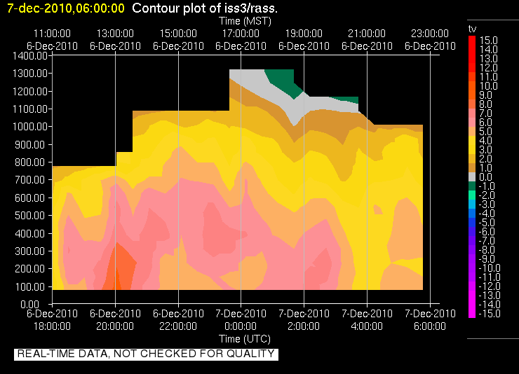
We have two soundings for 00 UTC on the 7th (5 PM local), both of which show very similar profiles. A fairly shallow and nearly isothermal layer extends from the surface, capped by a well mixed (dry adiabatic profile). In fact these soundings even support the possibilty of some weak convection (assuming it a parcel can either be lifted out of the shallow stable layer or from an elevated source... like the mountains). This potential was realized shortly after these soundings as a semi-organized band of precipitation pushed across the Wasatch Front providing locally heavily rain (in the mountains there was a lot of graupel). A big question for us was what happended during this period (around 02 UTC Dec 7th?). Fortunately we have some continuously monitoring intstruments to help figure that out, namely the Radio Acoustic Sounding System (RASS). Data indicated that around the time of this precipitaiton, a monotonically decreasing temperature profile existed with a fairly consistent lapse rate. See for yourself here. This would suggest that during the rain fall and convective burst that the atmosphere was able to freely mix for some short period of time. So was the cold pool dead as of then?


The plot thickens as we look at the 06 UTC sounding. Despite the rain and convection, we once again observe a shallow isothermal layer. If the cold pool was destroyed previously where did this layer come from and why is it so similar in structure to that observed before the rain?

By Wednesday morning (12 UTC Dec 7 th), conditions at the surface had cooled a bit, converting the previously isothermal layer to a true inversion. The air above this layer was once again nearly dry adiabatic. The more significant change observed at this time was appearance of a subsidence inversion aloft, indicative of large scale processes that would soon favor the trapping of air within the valley. But there was another variable, SUN!

Daytime heating, something that had been in short supply, helped to remove the surface based inverison by late moring (18 UTC) favoring a lapse rate that was close to moist nuetral up through 700 hPa. A tell tale sign of surface heating was observed at this time... fair weather cumulus over the valley (not just the mountains). The 00 UTC sounding further coroborates this notion showing a nearly dry adiabatic lapse rate from the surface up to the lowering subsidence inversion, which was now just below the crest level of the Wasatch Mountains.

So IOP 1 ended either during the mix out phase near 02 UTC on Dec 7th or during the day on Tuesday (between 12 UTC and 00 UTC) right? And IOP 2 began as the new subsidence inversion descended into the valley...

Well it did in our books, but there is a bit of a hitch and its name is the Great Salt Lake. While the atmosphere was well mixed over the land, surface observations (shown below) indicated that the lake remained cold and foggy (not shown, but RH values > 95 %) during this time.


We would in fact see the influence of the lake on Wednesday, as a lake front was observed which advected colder and damper air into the Salt Lake Valley during the afternoon. That air was the remains of the Cold Pool from IOP 1... so did it ever end? In the end it is just a semantic issue, but it certainly highlights the potential for the lake to act as a source of cold and poluted air.

The wind transition associated with that lake front was well captured by the U of U mini Sodar deployed at the Playa site near the lake. Note the strong and organized NW flow near 21 UTC:


We have scaled back observations for IOP 2 to conserve resources, but we are still very much in the midst of a persistent cold air pool. A weak system on Friday will try to mix it out, but it doesn't look promising. Over the weekend a strong ridge will build across the Mountain west and Cold Air Pool conditions are expected!

Tuesday, December 7, 2010

Morning inversion

This morning there was a pronounced nocturnal inversion visible across the Salt Lake Valley. The below photo was taken from above the Salt Lake City Cemetary at 11th Avenue around 9:30AM. What's interersting about this photo is the very distinct two layers against the East bench. Here we are looking south across the valley at Big and Little Cottonwood canyon in the distance.


Reviewing the 12z SLC sounding, there was a pronounced ground inversion capped at 860mb with a small flattening near 750mb and then a relatively deep layer extending up to 650mb. By mid day the entire valley was likely well mixed to 650mb with surface-driven cumulus across the region. And with a northwest flow aloft, perhaps we will see some of the trapped valley aerosols disperse a bit more before the next Cold Air Pool event settles in for a stay.


The ingredients are right for another Cold Air Pool event, which will give us IOP2 over the next period, but the duration and strength is in question. I'll let Neil or Erik post the details on IOP1 ending and IOP2 starting up.

Monday, December 6, 2010

IOP1: Cold Fronts and Warm Fronts

We've been quite busy with PCAPS operations for the past few days so sorry for a lack of updates.

Weather conditions within cold air pools are frequently described as quiescent. This cold pool apparently hasn't read the published literature! Dense fog fronts, strong winds, rapid temperature variations, freezing rain and drizzle, horrendous air quality have all been observed since my last posting... not really quiescent if you ask me. And that is why we've been so busy... and why I'll post a few installments to get you up to speed.

Lets start with some of the interesting events on Thursday night and early Friday morning (Dec 2nd-3rd). A weak short wave trough moved just north of the region, clouds overspread northern Utah, and some light rain fell across the Salt Lake Valley, especially up on the east bench. Accompanying the shortwave trough aloft was a regional pressure gradient that accelerated low altitude winds from the South (low pressure to the north, high pressure to the southeast). Terrain channeling may have helped to orient these winds along valley. The net result was that strong south winds penetrated to the surface at the south end of the valley, effectively 'mixing out' the inversion and advancing a 'warm front' like structure north through the valley. At 06 UTC on Dec 3rd (11 PM local) the advance of the cold pool edge accomplished its northern most extent. Some of the PCAPS team members who live in the south end of the valley observed this transition in person at their homes and described a sudden whoosh and temperature warm up.

However this localized 'mix out' was relatively short lived. In the predawn hours of Friday morning a weak pressure trough swung south across the valley, and effectively reversed the local pressure gradient. The cold pool responded by running back to the south, now resembling a cold front, rapidly engulfing all of the valley.

This evolution is summarized in the following figures:

06 UTC 12 UTC

13 UTC 14 UTC

The temperature/humidity and vector wind traces from around 9000 S and I-15 show both the retreat and return of the cold pool at that location.


Later during Friday afternoon another interesting transition took place. The incredibly hazy air trapped within the cold pool ascended in altitude engulfing locations that had been clear earlier in the day. It is unclear without more detailed analysis what caused this vertical expansion but one hypothesis is that a very shallow cold front moved across the region, gliding over the top of the colder air within the cold pool. This may have knocked some of the strength off of the capping portion of the cold pool and allowed for the upward expansion. Some evidence for this can be seen by comparing the morning sounding with the evening one:


It is readily apparent that nearly all of the cooling in the lower atmosphere took place near the inversion top and that overall the stability in the lowest levels has decreased. While there was no clear indication at the surface of a true cold frontal passage, analysists at the Hydrometeorological Prediction Center (HPC) seem to believe that a cold front passed during this time.


Overall it was an exciting 24 hour period and one that will be examined with more detail in the future.

Tomorrow I'll bring you all (if anyone actually reads this blog) up to date on some of the more recent changes in the cold pool including dense fog and possible break up.

Friday, December 3, 2010

Glider Test Flight Over Saltair a Success

In anticipation of today's potential mix out, local paraglider pilot Chris Santacroce and a small team from the U of U finally had a good window to test deploying an instrumented Powered Paraglider (PPG) at the edge of the Great Salt Lake over Saltair yesterday (December 2, 2010). The goal was to sample the land / lake interaction in a strong Cold Air Pool and capture the vertical structure in detail. By attaching a GRAW Sonde to the pilot controlling the glider we hoped to create a "new" type of instrumentation that could sample cross sections and vertical profiles of the air.

Paragliders can fly at very low speeds without stalling (around 15 to 20 mph) which allows unique sampling of the air by a human pilot. Imagine being able to ask a balloon to stop at a certain height, sample a cross section, spiral back to the ground, then ascend just above the cold pool and take pictures before returning to the launch location.

A powered paraglider is also unique because of the small space required to take off. This allows us to deploy the glider quickly and with few resources from any number of locations within the Salt Lake Valley. Of course, most first prototypes suffer in the glamor department but this is what we ended up with (sonde mounted on helmet):


The first flight attempt yielded no problems and good quality data. Chris flew for around 40 minutes completing cross sections out to the lake's edge, then back over I-80. Each transect was 100 meters higher than the last until finally the glider was above the Cold Air Pool, where he was met with a 20 knot south wind. We communicated by texting via iPhone and two-way radio. Chris was able to snap a few photos along the way to document the flight in a little more detail.

Photo by Chris Santacroce, Dec 2, 2010.
Looking south over Saltair from 350 meters AGL.


Photo by Chris Santacroce, Dec 2, 2010.
Looking NNW over Saltair from 325 meters AGL.

Yes. Those are feet at the bottom of the photos. Note in the second photo: the lake fog to the west of Lake Point was still quite thick mid day.

Initial analysis of the observations showed that within 150m starting at 250m AGL, temperatures increased just over 9C, which validated well with nearby balloon launches. And where a regular sonde only samples a single vertical profile with few observations in a shallow Cold Air Pool, we were able to maintain flight within the inversion and gather considerably more data.

Our thanks to Chris Santacroce for helping design a working prototype. Chris is a talented pilot and co-creator of the Red Bull Airforce team. We are extremely lucky to have his skills and time donated for PCAPS and we hope to deploy many more glider flights throughout the project.

Thursday, December 2, 2010

Persistent indeed!

The purpose of this field campaign is to study Persistent Cold Air Pools (PCAPs), and that is exactly what we've got. The Salt Lake Valley has now been in continuous Cold Air Pool conditions since Monday night, and it is not exactly clear just when its going to end. Persistent indeed. We've decided to really ramp up observations this evening and into tomorrow morning in the hopes of capturing some modifications to the cold pool structure accompanying the advent of strong winds above the inversion followed by arrival of some moderately colder air aloft tomorrow. Will we mix out? Will parts of the valley mix out? ... tough to say, which is a big part of why we're studying this. If we don't mix out the already dismal air quality is wont to get worse (courtesy of Utah DAQ).


To give you a sense of what dismal air quality looks like, here is a picture I took this morning from high on the slopes above downtown Salt Lake and the University of Utah.


Today also marked a first for the PCAPS team: With the help of expert pilot and weather enthusiast Chris S. we conducted soundings of the boundary layer with instrumentation mounted on a motorized paraglider. We hope to continue to use this sampling method to augment our measurements of the lower portions of the Cold Air Pools especially near the Great Salt Lake, the influences of which can play an important role. Hopefully we'll be able to share some of the pilots perspective in a future post here.

The cold pool itself has reduced in vertical extend over the past 36 hours, but has only gained in potency. Here are some of the soundings from today:


A few of the issues at play today were strong warm air advection above the inversion top, possible low level jet type dynamics caused by topographic channeling and regional pressure gradients, and the inability of strong winds to penetrate to the surface due to such immense stability.

All eyes are now on tomorrow, which will be a make or break day for this event.